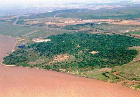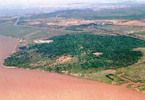
Oblique aerial view of Côte
Blanche Island Field. Note the topographic expression of the crest of the
diapir marked by vegetation. Light spot on the left side of the elevation
if a salt mine. Canal beyond the elevation is the Intracoastal Waterway.
(Click to see a larger picture) |
Côte Blanche Island Field is a 50-year-old field in southern Louisiana.
Discovered in 1948, it has gone through a long and prolific life, but by
1994 it was nearing its end. After its production peak in the 1970s, when
it was producting close to 8000 barrels of oil per day, its production steadily
decined as the known reservoirs were being depleted. It seemed that the
only reasonable thing to do with the field was to sell it. Toward the end
of 1994 the field was producing less then 300 barrels of oil per day and
losing money at a ferocious rate.
In 1995 I was teamed with Mike
Fontenot, a can-do production/reservoir engineer, and several drilling engineers.
Together, taking advantage of a newly discovered play, we drilled 13 wells
in 2 1/2 years, brought the field production to over 6000 barrels a day and
sustained it for several years.
This revitalization of the field
was possible thanks to a recently discovered sub-salt-overhang play. This
play hinges on three factors:
1.- improved seismic imaging of the salt-sediment interface
2.- better understanding of the stratigraphic architecture and depositional
setting of the reservoirs, and
3.- better understanding of the fault framework and the overall structural
setting of the salt diapir.
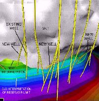
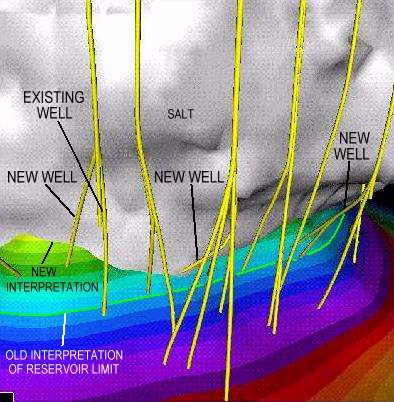
Detail of the newly discovered
play under the flank of a salt overhang. Yellow line indicates where the
boundary of the reservoir was thought to be before this study. Based on
improved seismic imaging of the salt, it was discovered that the reservoir
boundary was much farther updip. That translates into millions of barrels
of newly discovered oil reserves. Note where new wells were drilled as sidetracks
of existing wells. Colors on reservoir surface represent depth.
Click to see a larger picture
(From Kolarsky, 1996) |
Improved seismic imaging of the salt-sediment interface allowed us to
better place wells close to the salt edge and thus recover remaining, previously
undiscovered attic oil reserves.
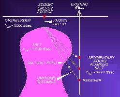
Principle of seismic
refraction imaging of salt. A seismic energy source is placed above the
apex of the salt diapir and detonated. The seismic wave propagates downward
at the interval velocity (vint) of the overburden. Obeying Snell's
Law it refracts and propagates at vint of salt until it exits
into the sedientary rocks flanking the salt. There it travels at vint
of the sedimentary rocks until it reaches a receiving device (geophone) placed
in an existing well. From the travel time from source to receiver, the direction
from which the signal strikes the receiver, the known depth of salt below
the receiver, and the vint of the overburden, salt anf flanking
sedimentary rocks, one can calculate the position of the location of where
the wave exited the salt. Those locations define the shape of the salt boundary.
Click to see a larger picture
(From Kolarsky, 1996) |
An improved understanding of the salt tectonic history of the diapir and
the related sequence stratigraphic character of the sedimentary rocks enveloping
the salt provided better clues to reservoir characteristics, size and continuity.
Sand quality and distribution proved to be controlled (not surprisingly)
by the depositional setting of the sandstones and by their tectonostratigraphic
relationship with the growing salt diapir (reactive, active and passive diapiric
stages).
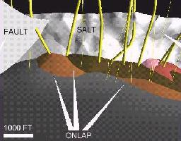
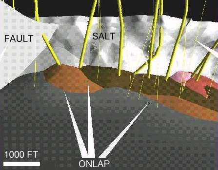
Detailed architecture
of individual sandstone reservoirs onlapping each other along the edge of
the salt diapir.
Click to see a larger picture
(From Kolarsky, 1996) |
However, despite this new geologic outlook on the field, if conventional
high-cost straight holes had been used, most of the oil would probably still
be sitting peacefully in the reservoirs. What made this play such a sounding
success was the know-how of our driling engineers who took advantage in recent
advances in short-radius directional drilling technology. This allowed us
to drill short-radius sidetrack holes from idle wells on the flanks of the
salt diapir. These wells were drilled at a third of the cost of a new well
and in a quarter of the time.
In all, we added over 10 million
barrels of new reserves to the field (10% of the field total size) and extended
its life for many years.
In these abstracts is the geoscience story behind this successful project.
|